검색결과 리스트
complexity maps에 해당되는 글 6건
- 2008.07.15 Complexity Maps 4. Marcos Weskamp - News Map / Social Circles
- 2008.06.29 Complexity Maps 3. Thomas Laureyssens - Pedestrian Levitation
- 2008.06.29 Complexity Maps 2. Mark Lombardi - World finance corpotation and associates
- 2008.06.29 Complexity Maps 1. They Rule
- 2008.06.26 WDC Seoul Membership Orientation
- 2008.06.26 [2008] TORINO International summer design school
글
Complexity Maps 4. Marcos Weskamp - News Map / Social Circles
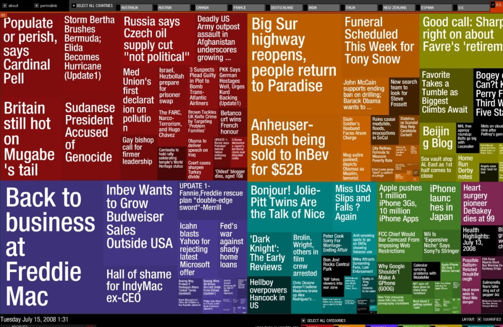
www.marumushi.com/apps/newsmap/newsmap.cfm
각 분야별 뉴스의 가장 중요한 헤드라인을 시각화한 어플리케이션. 각 섹션은 더 최신 기사일 수록 밝은 톤으로, 이슈가 더욱 부각될수록 면적이 더 커짐.
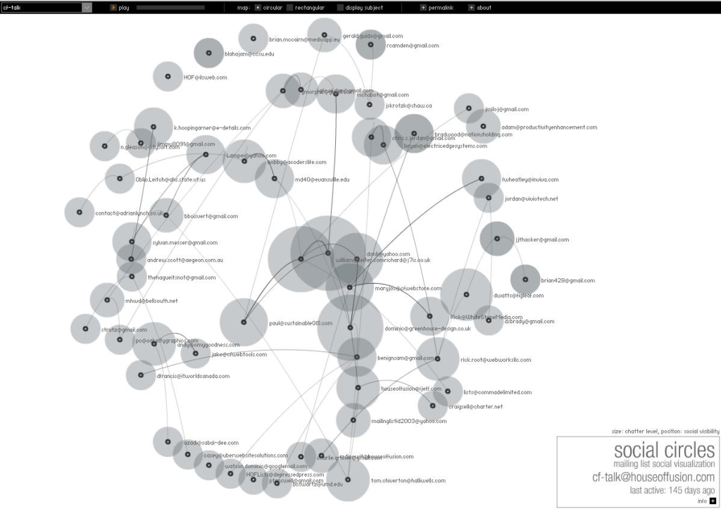
Social Circles
http://www.marumushi.com/apps/socialcircles/index.cfm
메일링 리스트를 통해 사회 네트워크를 시각화한다. 거의 실시간으로 그들이 보내는 메일들간의 관계를 볼수 있다.
Marcos Weskamp
현재 사람들은 정보의 범람 속에서 작업하고 있습니다. 너무나 많은 정보가 있습니다. 우리는 도심의 어디서나 잡지, 광고, TV, 라디오 등을 통해 흘러나오는 정보의 홍수 속에서 인간의 감각을 자극하는 수많은 이미지들을 접하고 있습니다. 인터넷은 매우 훌륭한 커뮤니케이션 도구이지만 매일 지속적으로 과도한 정보를 처리하고 있습니다.
오늘날 인터넷은 새로운 과제를 안고 있습니다. 규제되지 않은 다량의 정보 배포방식을 해결하기 위해서는 대규모 데이터를 체계화, 간소화, 분석할 수 있는 새로운 시각적인 패러다임이 필요합니다. 새로운 UI 필요성도 많은 양의 정보를 처리할 때 등장하는 과제 중의 하나입니다. 경우에 따라 정보를 간단하게 시각적으로 재구성하기만 하면 완전히 새로운 방식으로 정보를 인식할 수 있게 됩니다.
<Macromedia MAX 2005 Korea / 세션 소개>
'프로젝트 > 2009 TORINO workshop' 카테고리의 다른 글
| [작업] Complexity Maps (2) | 2009.09.05 |
|---|---|
| Christian Nold (1) | 2008.07.08 |
| Complexity Maps 3. Thomas Laureyssens - Pedestrian Levitation (0) | 2008.06.29 |
| Complexity Maps 2. Mark Lombardi - World finance corpotation and associates (0) | 2008.06.29 |
| Complexity Maps 1. They Rule (0) | 2008.06.29 |
설정
트랙백
댓글
글
Complexity Maps 3. Thomas Laureyssens - Pedestrian Levitation
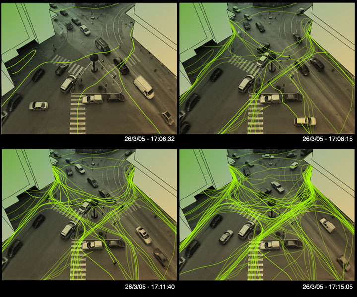
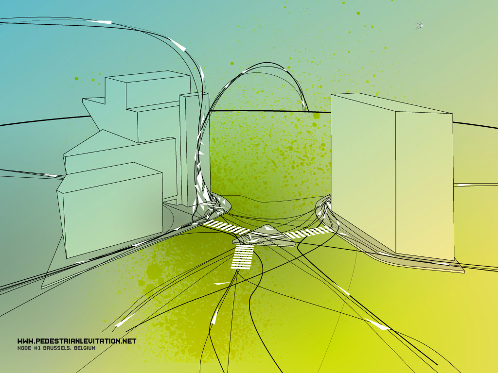
Pedestrian Levitation
www.pedestrianlevitation.net
공공예술(거리예술) 프로젝트, 횡단보도에서 실제 보행자의 움직임 비디오카메라로 녹화하여 시각화하고, 그 데이터로부터 지배적인 방향성을 발견하여 그것을 토대로 가상의 방향성이 있는 삼각형을 실제 현실세계의 도로부터 빌딩 벽까지 이어지도록 배치했다. 이 작업으로 인해 공공장소의 벽이 예술적으로 해석된 아트워크의 캔버스가 될 수도 있으며, 디자인 프로세스로서의 의의도 가지게 된다.
'프로젝트 > 2009 TORINO workshop' 카테고리의 다른 글
| Complexity Maps 4. Marcos Weskamp - News Map / Social Circles (0) | 2008.07.15 |
|---|---|
| Christian Nold (1) | 2008.07.08 |
| Complexity Maps 2. Mark Lombardi - World finance corpotation and associates (0) | 2008.06.29 |
| Complexity Maps 1. They Rule (0) | 2008.06.29 |
| WDC Seoul Membership Orientation (0) | 2008.06.26 |
설정
트랙백
댓글
글
Complexity Maps 2. Mark Lombardi - World finance corpotation and associates
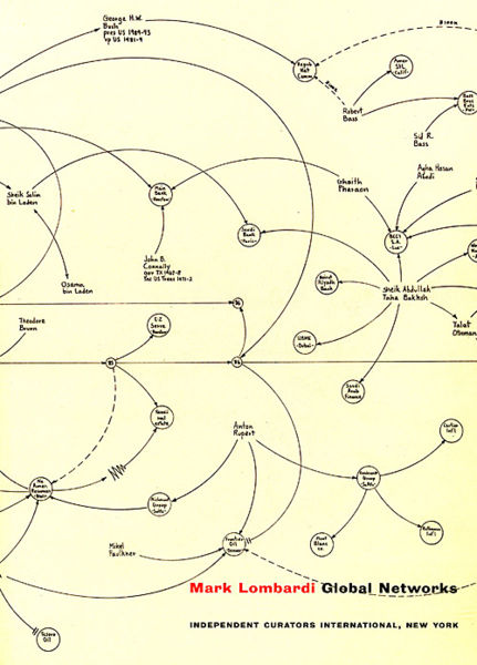
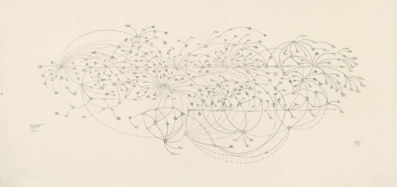
Mark Lombardi
http://www.pierogi2000.com/flatfile/lombardi.html
1994년부터 "narrative structures"라는 금융과 역사적으로 중요한 스캔들에 대한 방대한 데이터를 정리하여 다이어그램으로 표현하여 독자에게 정치,사회,경제적 영향력의 실체와 그 관계를 폭로하는 프로젝트를 해오고 있는 컨셉예술가
컴퓨터 프로그램이 아니라 연필로 직접 드로잉한다
'프로젝트 > 2009 TORINO workshop' 카테고리의 다른 글
| Christian Nold (1) | 2008.07.08 |
|---|---|
| Complexity Maps 3. Thomas Laureyssens - Pedestrian Levitation (0) | 2008.06.29 |
| Complexity Maps 1. They Rule (0) | 2008.06.29 |
| WDC Seoul Membership Orientation (0) | 2008.06.26 |
| [2008] TORINO International summer design school (0) | 2008.06.26 |
설정
트랙백
댓글
글
Complexity Maps 1. They Rule
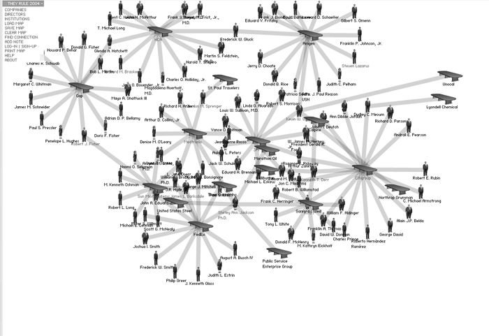
www.theyrule.net
미국 시장 내에서 가장 영향력있는 회사들의 디렉터이자 다른 회사나 위원회에서도 권력을 발휘하고 있는 이들의 관계를 시각화하고 있다. 인터렉션을 가미하여 사용자가 원하는 회사별, 디렉터별로 검색과 데이터 배치가 가능하도록 했으며, 최종 결과물을 저장, 출력도 할 수 있다. 정보가 현실과 100% 일치하지는 않지만 몇년 간 지속적으로 업데이트를 해오고 있으며, 이용자가 직접 코멘트도 남길 수 있다.
- 나름 디렉터들의 모습이 조금씩 다른게 묘미. 뚱뚱하거나, 보통 체격이거나, 말랐거나. :)
- 조직의 구조를 시각화하는게 과제였던 CI 수업 파이널 때 참고가 될 수 있었을텐데 아쉽다.
'프로젝트 > 2009 TORINO workshop' 카테고리의 다른 글
| Christian Nold (1) | 2008.07.08 |
|---|---|
| Complexity Maps 3. Thomas Laureyssens - Pedestrian Levitation (0) | 2008.06.29 |
| Complexity Maps 2. Mark Lombardi - World finance corpotation and associates (0) | 2008.06.29 |
| WDC Seoul Membership Orientation (0) | 2008.06.26 |
| [2008] TORINO International summer design school (0) | 2008.06.26 |
설정
트랙백
댓글
글
WDC Seoul Membership Orientation
윤교수님의 추천을 받아 서울시에서 지원하는 토리노 섬머스쿨 워크샵에 참가 신청을 했었고, 운 좋게도 최종 참가자로 선정되었습니다.
이 워크샵 참가 지원은 2010년 서울 디자인 수도 홍보 사업의 일환으로 2008년 디자인수도 시범도시인 토리노에서 개최되는 워크샵 참가후에도 '2010 세계디자인수도 서울 홍보단'이라는 이름하에 보고, 전시, 홍보 등의 활동도 하게 된다네요.
24일에는 처음으로 서울시청에서 오리엔테이션 및 관계분들과의 만남을 가졌습니다.
함께 가는 분들은 총 10분 (그리고 지도 교수님 2분)으로 석사, 학사 3-4학년으로 구성되었으며
제가 속한 'COMPLEXITY MAPS' 부문에는 서지민, 김하나, 김용님께서 함께 가십니다.
'프로젝트 > 2009 TORINO workshop' 카테고리의 다른 글
| Christian Nold (1) | 2008.07.08 |
|---|---|
| Complexity Maps 3. Thomas Laureyssens - Pedestrian Levitation (0) | 2008.06.29 |
| Complexity Maps 2. Mark Lombardi - World finance corpotation and associates (0) | 2008.06.29 |
| Complexity Maps 1. They Rule (0) | 2008.06.29 |
| [2008] TORINO International summer design school (0) | 2008.06.26 |
설정
트랙백
댓글
글
[2008] TORINO International summer design school
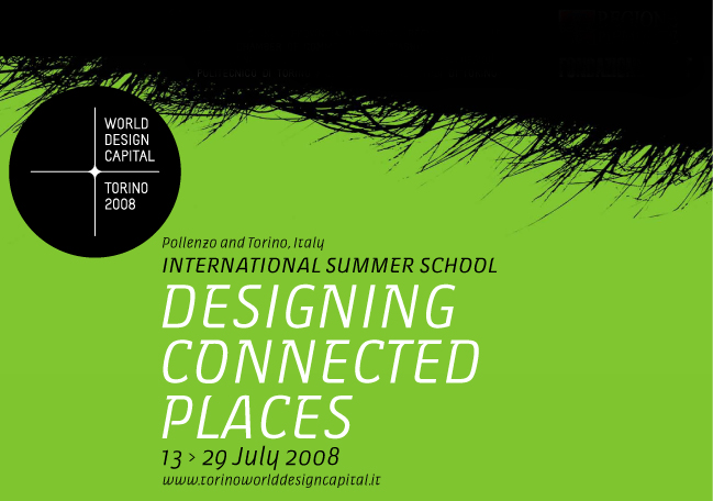
PROJECT DESCRIPTION
Designing Connected Places is an international summer design school. But there is much more. It is also a programme for action throughout Piemonte. Using the tools of design, solutions will be outlined for 6 problems expressed by 6 local bodies. These are: health and well-being, food and new food networks, urban mobility, security and quality of life in the city, new production systems, and forms of representation of the region and its communities.
The summer school brings out a new definition of the "local" and a new role of design:
a connected local, understood as local in the era of networks and high connectivity, understood as a concept able to promote original development strategies.
A selected group of young designers of different nationalities will be called on to participate. Guided and stimulated by project leaders and visiting professors of great and proven international experience, they will work intensely for a week on themes indicated by local "clients" and prepared by meta-design work conducted by a group of researchers from various design schools.
Designing Connected Places is:
- 6 themed workshops at Pollenzo
- 1 design studio in Torino
- 6 meetings with international visiting professors (open to the public)
PROJECT PROCESS and DETAILS
Designing Connected Places is an exercise of concept generation organised in 6 workshops of one week each and which involves an international group of young designers and project leaders.
Its result will be an ample set of design ideas that propose practical solutions to well-defined problems and that, at the same time and as a whole, give a vision of the potential of design for local development.
The concept generation exercise is made more effective by the support of appropriate activities of preparation and post-production of the results: analytical and planning work - the "meta-design" - conducted before and after the concept generation workshops by a team of researchers from Italian design schools
6 WORKSHOPS LIST
The workshop is an original form of intervention in the metropolitan and regional area.
Six specific themes significant for Piemonte branch out from the general topic of "Design for local development":
- health
- mobility
- security
- food networks
- the representation of complex phenomena
- distributed production systems
The summer school stimulates the use of knowledge and competencies typical of contemporary design to enhance social and territorial resources, to solve specific problems in Piemonte, and to promote an approach oriented towards environmental sustainability.
COMPLEXITY MAPS
Design for the representation of places and communities
July 22 > 29 - Pollenzo, Italy
Background
Torino is a city on the move. The tradition forms of representation are obsolete or inadequate to depict the current reality and the dynamics in progress.
Project question
How can the city be made legible and comprehensible, understood as a complex organism and as a web of physical and social networks?
Workshop leader : Christian Nold, designer
Local team leader : Paolo Ciuccarelli
Commitment : Urban Center Metropolitano - Torino
Description
The urban territory is a system whose complexity is growing, in which a multitude of tangible and intangible flows (people, goods, information) stratify and interconnect.
Faced with all this, the traditional modes of mapping and representing the city appear entirely inadequate: the representations of the new physical and social networks, like that of their individual and collective life, are a new challenge for the design of communication. The representation of the phenomena demands the gradual abandonment of classical visual languages, i.e. of maps that lay their trust chiefly in the topological and geographical metaphor.
Overcoming these limits means building a new representation of the city: a collective vision capable of defining and visualising the new concept of urban space and, more in general, social spaces.
The theme, proposed in collaboration with the Urban Center Metropolitano of Torino, aims to produce visualisations in the form of diagrams and maps of relationships that induce a new way of viewing human-city interaction, and also useful for outlining new criteria for its development.
'프로젝트 > 2009 TORINO workshop' 카테고리의 다른 글
| Christian Nold (1) | 2008.07.08 |
|---|---|
| Complexity Maps 3. Thomas Laureyssens - Pedestrian Levitation (0) | 2008.06.29 |
| Complexity Maps 2. Mark Lombardi - World finance corpotation and associates (0) | 2008.06.29 |
| Complexity Maps 1. They Rule (0) | 2008.06.29 |
| WDC Seoul Membership Orientation (0) | 2008.06.26 |

RECENT COMMENT